ΑΙhub.org
AI tools for assessing zero-deforestation commitments in Vietnam
By Andres Perez-Uribe and Louis Reymondin
Climate change is not merely an environmental problem. Today it can be considered the number one threat to humanity. Forests are significant sinks for carbon-dioxide pollution, which is the single-biggest driver of climate change. Unfortunately, the overall rate of deforestation is increasing year after year, driven by demand for products like timber, rubber, palm oil, cattle, and coffee.
During the 9th Conference of Parties to the Convention on Biological Diversity (CBD COP9) in May 2008 in Bonn, delegates of 67 countries pledged support for WWF’s call for zero net deforestation by 2020. Since then, many companies have made ambitious forestry conservation commitments. For instance, in 2010, Nestlé committed to ending deforestation in their supply chain by 2020. Similarly, other large groups including Walmart, Unilever, L’Oréal, Danone, etc, have announced zero-deforestation commitments. However, it is not easy to verify the achievement of these commitments and the current solutions for verifying forest conservation do not fully meet market expectations.
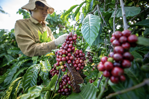 Credit: © 2020 Alliance of Bioversity International and CIAT/Trong Chinh
How are we going to assess those commitments?
There is a clear need for solutions to help companies with their “zero deforestation” commitments. Commodity maps for land uses such as oil palm, soy, beef, cocoa, rice and maize already exist. However, there are no equivalent systems combining climate impact suitability maps to detect future areas at risk of deforestation and the unique ability to detect smallholder agroforestry systems such as coffee. Coffee is especially challenging due to the heterogeneous cropping patterns and the presence of shade tree canopy causing obstruction of satellite data and making it easy to confound perennial tree systems with forests.
Thanks to the Coffee Vision project, led through a partnership between University of Copenhagen and the Alliance of Bioversity International and the International Center for Tropical Agriculture [1], we are developing a smart monitoring tool to support the certification of sustainable coffee plots in Vietnam. For the first time the precise location of coffee plots will be identified remotely and, past and present coffee driven deforestation will become radically more visible, and areas of future risk will be identified. Coffee Vision is a project that contributes towards achieving the 15th sustainable development goal adopted by all United Nations Member States in 2015, that is, to “sustainably manage forests, combat desertification, halt and reverse land degradation, and halt biodiversity loss”.
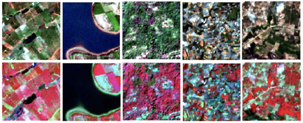
Figure 1. Different land-uses as seen from space (Sentinel-2 satellite images on 10m resolution). From left to right: coffee plots, a lake, forest, urban and other crops. First row shows RGB images and the second row shows a combination of red, green and infra-red bands.
Coffee Vision: leveraging satellite images with Machine Learning
The project leverages satellite imagery (like those shown in Figure 1) and the latest research and developments in machine learning (e.g., the use of convolutional neural networks) to identify coffee plots down to smallholder level, including identifying the presence or absence of shade trees and other agroforestry systems. This is overlaid with a detailed history of deforestation to pinpoint coffee driven deforestation and climate projections are used to highlight forests at risk of conversion to coffee in the future.
To build models able to spot coffee crops we started using Sentinel-2 images provided by the ESA without any cost for research purposes. Those images offer a 10m resolution, but are only available since mid-2015, date of the launch of that satellite. We then proceeded to use Landsat-8 images from NASA, because even if they have lower resolution (30m), the corresponding satellite was launched in 2013, allowing us to analyze land-use for at least seven years. We use Google Earth Engine to gather and pre-process the images before downloading them to our computing servers.
The presence of clouds in the atmosphere makes it impossible for the satellite to get optical images of the land every time. To deal with this problem, we created composites of images from several dates to obtain images at a lower temporal resolution but with valid data. A particular problem to deal with consists in exploring the different channels (i.e., different wavelengths) available from the satellite sensors. We have the possibility of using visible wavelengths (R, G, B) and several infra-red channels.
To train the models we use annotated images of coffee plots and forest, but also of other confounding land-uses including tea, pepper, rice, and cocoa crops, and other land-uses (urban, water bodies, etc.). CIAT has collected more than 40,000 observations of land-use all over Vietnam. Our current best models are capable of detecting the coffee crops using 10m resolution images (Sentinel-2) and 30m resolution images (Landsat8) with an accuracy (i.e., the accuracy gives the percentage of correct predictions) of 73% and forests with an accuracy of 84%. As far as the detection of deforestation over time, our best models trained with data from 2017 can detect coffee plots in 2021 with an accuracy of 77% and forests with an accuracy of 76%. Moreover, they can predict coffee plots and forests in 2014 with an accuracy of 66% and 74% respectively.
The foundational capabilities of Coffee Vision will be: location of coffee plots, presence of shade trees, dataset of the location, history and pattern of deforestation and proximity to protected or sensitive areas. These features will reduce costs of registering new certified farms and verifying deforestation and shade tree status of farms according to both third-party and in-house sustainability standards. Moreover, the tool will also provide a cost-effective way for actors currently operating outside the certification standards to identify and address their deforestation impacts. Finally, it will open the door to new advisory services that the certification industry offers, including the analysis of carbon sequestration, climate impacts, water system effects, and national level crop land analysis.
AI for sustainable Agriculture: event 12 November 2021
![]() Within the framework of the Coffee Vision project funded by the University of Applied Sciences Western Switzerland (HES-SO), we are organizing the “AI for sustainable agriculture” conference at the HEIG-VD site in Yverdon-les-Bains, Switzerland, with the support of the CLAIRE Research Network. It will take place the 12th November 2021 on site and online.
Within the framework of the Coffee Vision project funded by the University of Applied Sciences Western Switzerland (HES-SO), we are organizing the “AI for sustainable agriculture” conference at the HEIG-VD site in Yverdon-les-Bains, Switzerland, with the support of the CLAIRE Research Network. It will take place the 12th November 2021 on site and online.
This conference gathers researchers, members of international organizations or NGOs, and employees of industries from the food and agriculture sector interested in the domains of AI and agriculture. The speakers are from academy (ETH-Zurich and HEIG-VD), industry (Picterra and ecoRobotix), and international organizations (CIAT, UN-Environment Program, and CLAIRE). Join us to pave the way of a more sustainable world!
Find out more about the event here.
—
[1] Coffee Vision received funding from the HES-SO and will continue thanks to the support of the Nordic Climate Facility (NCF)
tags: Focus on life on land, Focus on UN SDGs

AUAI is supported by: